
 |
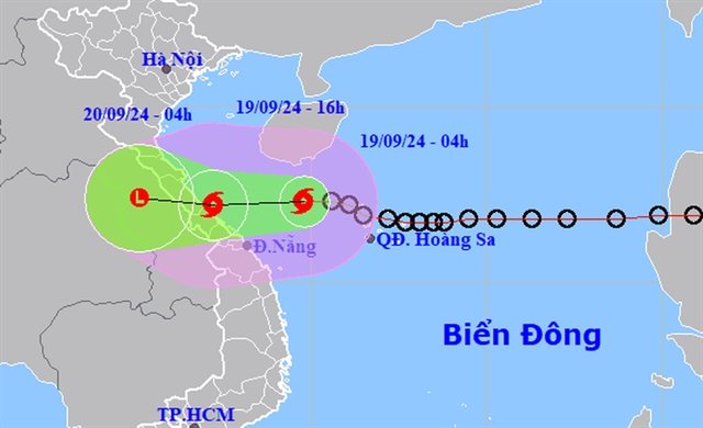
| Forecasted position and direction of Storm No 4 as of 4 am on September 19 – Photo NCHMF |
HÀ NỘI – Early this morning, the tropical depression located in the northeastern Paracel region intensified into Storm No 4 of 2024. Strong winds of level 6, with gusts up to level 7, were recorded at Cồn Cỏ Island, Quảng Trị.
As of 4 am, the storm’s centre was positioned at approximately 17.3 north latitude and 109.8 east longitude, about 210 km northeast of Đà Nẵng and 260 km east of Quảng Trị. The maximum sustained winds near the storm’s centre were recorded at level 8 (62-74 kilometres per hour), with gusts reaching level 10. The storm is moving westward at around 20 kilometres per hour.
By 4 pm today (September 19), the storm is expected to continue westward at a speed of 20-25 kilometres per hour, affecting coastal areas from Quảng Trị to Quảng Nam provinces. Winds near the storm's centre are forecast to remain at level 8, with gusts up to level 10, and the disaster risk level has been set at level 3. Affected areas include the western part of the northern East Sea (including the Paracel region), coastal waters from Nghệ An to Quảng Ngãi provinces (including Lý Sơn, Cù Lao Chàm, Cồn Cỏ, and Hòn Ngư islands), and inland areas from Hà Tĩnh to Quảng Nam provinces.
By 4 am on September 20, the storm is expected to weaken into a tropical depression over central Laos, with maximum wind speeds dropping below level 6. The affected areas will still include coastal waters from Nghệ An to Quảng Nam provinces, and inland areas from Hà Tĩnh to Quảng Nam provinces.
As a result of Storm No 4, strong winds of levels 6-7 (39-61 kilometres per hour) and waves of 2-4 metres are expected in the western part of the northern East Sea and coastal waters from Nghệ An to Quảng Ngãi provinces. Near the storm’s centre, winds will intensify to level 8 (62-74 kilometres per hour), with gusts reaching level 10 (89-102 kilometres per hour), and waves could rise to 3-5 metres, creating hazardous sea conditions.
Furthermore, due to the influence of a strong southwest monsoon, coastal areas from Bình Định to Cà Mau provinces, the southern central East Sea, and the southern East Sea (including the Spratlys region) will experience southwest winds of level 6, occasionally reaching level 7, with gusts of level 8-9 and wave heights of 3-5 metres, resulting in rough seas.
Coastal regions from Quảng Bình to Quảng Nam provinces should be on alert for storm surges of 0.3-0.5 metres, which, combined with high tides and large waves, could lead to erosion of sea dikes, flooding in low-lying areas, and other hazards. Boats in the affected regions are advised to be cautious of thunderstorms, strong winds, and high waves.
On land, from the morning of September 19, coastal areas from Hà Tĩnh to Quảng Nam provinces will experience increasing wind speeds of levels 6-7, with areas near the storm’s centre reaching level 8 (62-74 kilometres per hour) and gusts of up to level 10 (89-102 kilometres per hour). Inland areas may experience gusts of levels 6-7. Strong thunderstorms ahead of the storm could lead to fallen trees, and roofs or billboards being blown away.
Heavy rainfall is expected from September 19 to 20 across the North Central and Central Central regions, with rainfall totals ranging from 100-300mm, and some areas potentially exceeding 500 mm. Particularly heavy rainfall, exceeding 150mm in 6 hours, is forecast for areas from Quảng Trị to Đà Nẵng provinces on September 19.
The Central Highlands and Southern regions will also see moderate to heavy rain and thunderstorms on September 19, with localized heavy downpours ranging from 20-40mm, and some areas potentially receiving over 70mm. Heavy rainfall could lead to flooding in urban areas and densely populated regions due to slow drainage. VNS