 |
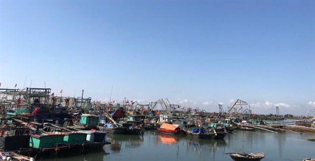
| Quảng Yên Town in Quảng Ninh Province has over 2,200 water vehicles that are notified to find safe shelter before the typhoon makes landfall. — VNA/VNS Photo Nguyễn Thị Vân |
HÀ NỘI — Typhoon Yagi, the third typhoon this year, is currently located 620km southeast of Quảng Ninh province, according to the National Centre for Hydro-Meteorological Forecasting's latest update on Friday morning.
The maximum wind speed near the typhoon's centre is at level 16 (184-201km/h), with gusts reaching level 17. It is moving westward at approximately 20km/h.
By 4am the following day, the typhoon’s centre is expected to be at approximately 20.6 degrees North latitude and 108.7 degrees East longitude. It will continue to move in a west-northwest direction at a speed of 15-20km/h, entering the northern Gulf of Tonkin, about 160km east-southeast of Quảng Ninh province. Wind speeds in the area are predicted to range from 134 to 166km/h.
The affected regions include the northwest of the East Sea and the eastern Gulf of Tonkin.
By 4pm that same day, the typhoon is expected to move west-northwest at around 20km/h, gradually weakening as it approaches the northeastern mainland. Wind speeds will decrease to 62-117km/h, and the affected area will extend to the Gulf of Tonkin, where a level-three natural disaster risk has been issued (on a scale of five).
By 4pm on Sunday, Typhoon Yagi is forecast to weaken into a low-pressure system in the northwest region, with wind speeds falling below 39km/h.
Boat mooring areas, aquaculture zones, dykes, and seawalls in the aforementioned dangerous regions are expected to be affected by strong winds and large waves. Low-lying coastal and estuary areas should also be on high alert for potential flooding due to storm surges and high waves.
Starting from Friday noon, waves in the Gulf of Tonkin, including the Bạch Long Vĩ and Cô Tô island districts, will reach heights of 2-4 metres, increasing to 3-5 metres, and up to 6-8 metres near the typhoon's eye.
By Friday night and early Saturday morning, coastal waters from Quảng Ninh to Thanh Hóa provinces will see wave heights of 2-3 metres, rising to 2-4 metres, and eventually reaching 3-5 metres.
The Central Highlands and southern regions will experience moderate rain and thunderstorms, with some areas receiving heavy rainfall of 20-40mm, and localized areas exceeding 80mm. The northeast and areas from Đà Nẵng to Bình Thuận will have scattered showers and thunderstorms, with some locations seeing rainfall between 10-30mm, primarily in the late afternoon and evening.
From Friday night to Monday morning, the northern region and Thanh Hóa Province are likely to experience heavy rain and thunderstorms, with total rainfall between 100-350mm, and some areas exceeding 500mm. This heavy rain poses a risk of flooding in low-lying areas, flash floods in small rivers and streams, and landslides on steep slopes.
On Sunday, the northern region and Thanh Hóa Province will see moderate rain, with some areas experiencing heavy rain and thunderstorms, with common rainfall between 20-60mm, and certain locations exceeding 90mm. Particularly, the northwest will face heavy rainfall between 50-150mm, with some areas receiving over 250mm.
The risk of natural disasters due to heavy rain, tornadoes, and lightning is at level one. Residents are advised to remain vigilant against thunderstorms, tornadoes, and strong winds both before and during the typhoon. — VNS


