 |
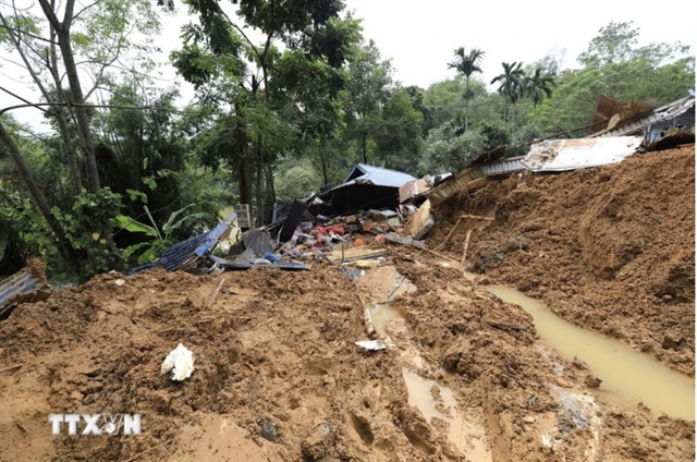
| Scene of the landslide in Má Mư Hamlet, Kim Bôi District of northern Hòa Bình Province. VNA/VNS Photo |
HÀ NỘI – The recent Typhoon Yagi and its aftermath caused severe devastation across many northern provinces and cities of Việt Nam.
In a matter of moments, mountainsides and hill slopes were swept away by raging floods, residential areas were submerged, and villages were levelled, leading to massive human and economic losses.
Rebuilding lives after storms and floods is an urgent and critical task in order to quickly stabilise residents’ lives and take care of victims’ health.
However, to ensure long-term safety and effective adaptation to natural disasters and storms, many experts believe that local authorities and citizens must jointly engage in reforesting and reducing greenhouse gas emissions.
It is also essential to quickly map out and provide detailed warnings for areas at risk of landslides.
Reforestation, a post-disaster recovery
Dr Mai Kim Liên, deputy director of the Department of Climate Change (under the Ministry of Natural Resources and Environment), said that over the years, Việt Nam has recorded 20 out of 21 types of natural disasters, causing severe damage, particularly to vulnerable populations.
The recent Typhoon Yagi and its aftermath alone caused the northern provinces and cities an initial estimated economic loss of over VNĐ40 trillion (approximately US$1.7 billion), with more than 350 people dead or missing and over 1,900 people injured.
According to Mai Văn Khiêm, director of the National Centre for Hydro-Meteorological Forecasting, it was the strongest typhoon in the past thirty years in the East Sea. The storm and its aftermath brought heavy rains, leading to widespread landslides, flash floods and severe damage in such provinces as Cao Bằng, Hòa Bình, Lào Cai, Yên Bái, and Quảng Ninh.
“Notably, in Làng Nủ Village, Phúc Khánh Commune, Bảo Yên District, Lào Cai Province, a landslide caused significant human casualties. The main cause was the prolonged heavy rainfall in the northern mountainous region over the past three months,” Khiêm said.
Meanwhile, Assoc. Prof. Dr Lê Văn Hưng, from the Institute for Environmental Treatment Research, emphasised that human activities, such as greenhouse gas emissions contributing to global warming, have exacerbated the severity of climate change. Rising temperatures increase the likelihood of forest fires, which in turn reduce the forest’s ability to retain water.
Recently, Trịnh Lê Nguyên, Director of the People and Nature Centre, shared grim news with the media, stressing that Việt Nam has lost many once-pristine natural areas, often regarded as 'paradises on earth'.
This transformation serves as a costly lesson about human responsibility. “Forests have been cut down for agricultural land, and unsustainable resource exploitation has drastically reduced biodiversity, disrupted ecosystems and degraded the environment,” he said.
Regarding the importance of natural forests in absorbing rainwater and reducing floods, environmental experts noted the deep root systems of natural forest trees, intertwined with one another, play a crucial role in maintaining the stability between soil and rock layers. However, when forests are destroyed, these connections are lost.
Prolonged heavy rains saturate the soil, weakening the links between layers and increasing the likelihood of landslides.
Thus, alongside post-disaster recovery for residents, localities must also focus on restoring forest ecosystems.
This is seen as an urgent task in the current decade, as humanity works together to prevent an ecological crisis.
Reforesting will help protect water resources and reduce the risk of mountain landslides.
Early zoning of landslide-prone areas
While restoring forest ecosystems is crucial, meteorology experts also noted that to effectively respond to natural disasters, it is necessary to continue investigating and surveying areas prone to landslides and rockslides and to map them out and issue early warnings for these areas.
The Ministry of Natural Resources and Environment will also review and adjust the operational procedures of the reservoirs, considering climate change scenarios, in order to improve flood prevention and reduction capabilities.
Moreover, the ministry will study and propose solutions to use some flood control capacity above the normal water level in large and vital reservoirs to improve downstream flood mitigation.
Additionally, the ministry will carry out public awareness campaigns, helping people recognise the risks and signs of potential landslides, flash floods and riverbank erosion, as well as teaching disaster response skills.
The relevant ministries, including the Ministry of Industry and Trade and the Ministry of Agriculture and Rural Development, must ensure that all reservoir operators strictly follow the operational procedures for river basins.
These procedures include the legal requirements for reservoir monitoring and information dissemination in accordance with the water resources law.
For localities, provincial and municipal People's committees must develop plans to implement the content of the National Project on Early Warning of Landslides and Flash Floods in the Northern and Midland Regions of Việt Nam, as per Prime Minister’s Decision No. 1262/QĐ-TTg.
These plans will focus on supplementing data on landslides and flash floods, creating risk maps at a scale of 1:10,000 or greater for high-risk areas.
Dr Trịnh Hải Sơn, director of the Institute of Geology and Mineral Resources, highlighted that future efforts must prioritise the creation of detailed landslide risk maps.
"If the mapping is not detailed to individual small points, it is not a warning, but merely a forecast. Furthermore, real-time landslide and debris flow warnings for high-risk areas must be implemented," Sơn said. VNS


