 |
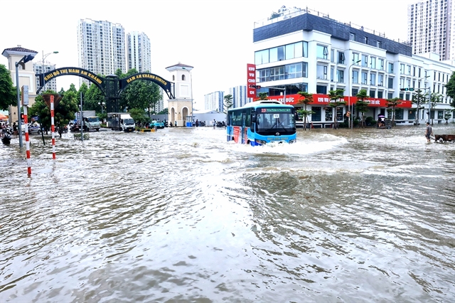
| Deep floods at a new urban area after a heavy rain on July 24 in Hà Đông District, making it difficult for vehicles to move.— VNA/VNS Photo Tuấn Anh |
HÀ NỘI — Many areas in Hà Nội were in inundated with extensive flooding following intense rainfall, a recurring problem over past years that has disrupted residents' daily lives.
In a narrow alley submerged in water, Hoàng Thị Hương, from Việt Hưng Ward, Long Biên District, pulled out her phone to call her husband for a pair of wellies.
The heavy rain on July 23 had left her alley severely flooded, with water levels rising between 50 and 65cm in places.
“This isn’t the first time our alley has flooded so deeply,” Hương said.
That evening, Hương left her motorcycle at a friend’s house close by, wore the wellies and waded through the water to her home.
The next morning, as the water had still not receded, she had to wade back out to retrieve her bike to go to the market for groceries.
On that day, her child had to miss school and her husband took a day off work to look after the child and clean up the flooded kitchen area.
Meanwhile, Hương’s neighbour, Phạm Thị Ngần, spent the entire night awake due to water entering her home on July 23.
“At 3am, I felt wet on my back and realised that the water had already flooded the entire house. That night, my husband and I, along with our three children, took turns bailing out the water,” she said.
Ngần said, drawing from experience with previous heavy rains, she built a sandbag barrier in front of her house to prevent flooding.
However, the downpour on the night of July 23 into the early hours of July 24 caused some sandbags to burst and water seeped through cracks in the walls, leading to flooding throughout her home.
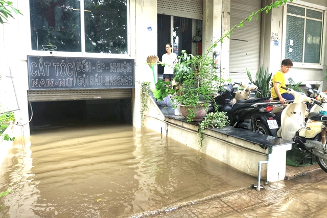
Similarly, the heavy rain on July 23 also disrupted the lives of many residents in An Khánh urban area, Hoài Đức District.
 |
| The basement of a house in An Khánh urban area is flooded after a heavy rain on July 24. — VNA/VNS Photo Tuấn Anh |
Trần Văn Nguyên, a resident at a local apartment complex, likened his home to an island whenever there was heavy rain.
Nguyên said that on the evening of July 23, it took him three hours to travel from his office in Cầu Giấy District to his home due to the heavy rain.
Upon reaching his apartment complex, he found the area severely flooded, forcing him to park his car by the roadside and walk about a kilometre to his home.
The following morning, he got up early to wade to work, packing an extra set of clothes in his bag just in case he got wet.
The Hà Nội’s Department of Transport said there were currently 30 'black spots' in the city that flood whenever it rained heavily, leading to traffic congestion and impacting residents' daily activities.
The spots included Nguyễn Khuyến Street, Hoa Bằng Street, the Phan Bội Châu - Lý Thường Kiệt intersection, Minh Khai Street (at the foot of Vĩnh Tuy Bridge) and Thăng Long Avenue.
A representative from Hà Nội Sewerage and Drainage Company Limited said due to the effects of typhoon Prapiroon, widespread rainfall occurred on the night of July 23 and the morning of July 24.
Rainfall measurements at 6am on July 24 ranged from 138mm to 295.8mm.
The extensive and prolonged heavy rainfall had caused water levels in rivers and lakes to rise, leading to numerous flood points in Long Biên, Cầu Giấy, Tây Hồ, Thanh Xuân, and Hà Đông districts. Notably, on Thăng Long Avenue, underpasses were severely flooded, submerging many motorcycles and making travel difficult.
Causes
The representative said the prolonged flooding in Thăng Long Avenue was due to the areas being lower lying compared to their surroundings.
Consequently, during heavy rains, water flowed rapidly towards these low areas, causing localised flooding.
Đào Ngọc Nghiêm, vice president of the Việt Nam Urban Development and Planning Association talked to Lao động (Labour) online newspaper, explaining that the flooding was because the water drainage system in the area was not connected to the main drainage channels.
Additionally, the main drainage systems outside the urban areas lacked pumping stations, resulting in insufficient drainage capacity during heavy rains.
Nghiêm said according to global best practices in flood prevention, about three to five per cent of land should be used as water retention lakes.
However, Hà Nội currently only had around two per cent of land used as reservoirs.
Although the city had numerous drainage channels, many of them were blocked or were not used effectively.
The city was now divided into three drainage zones, consisting of the north of the city and the left and right banks of the Đáy River.
However, local pumping stations to transfer water to main stations had not been fully established. Many pumping stations were still inadequate or yet to be built, he said.
Solutions
Therefore, Nghiêm recommended that existing drainage projects be reviewed and adjusted.
Additionally, regular maintenance of sewers, channels and ditches was crucial, along with comprehensive research into the river systems flowing through the city.
To fix the situation, the city is implementing several projects, such as upgrading the Phương Trạch Pump Station in Đông Anh District and improving the drainage system in the Yên Nghĩa Pump Station in Hà Đông District.
Moreover, numerous projects are in the planning stages, including the left bank of the Nhuệ River drainage system, the Hà Đông District drainage system on the right bank of the Nhuệ River, the Gia Thượng pumping station, the Cự Khối water retention lake and Thượng Thanh drainage channel in Long Biên District.
Trịnh Ngọc Sơn, deputy general director of Hà Nội Sewerage and Drainage Company Limited said in the long term, the city needed to invest in drainage infrastructure according to the urban planning framework, including new pumping stations such as Nam Thăng Long and Ba Xã as well as water retention lakes like Cổ Nhuế 1, Cổ Nhuế 2 and Phú Đô to mitigate flooding in the area.
In particular, for Thăng Long Avenue, the company suggested constructing temporary pumping stations such as Đìa Sáo to lower water levels in local channels and Đồng Tép to pump water from the Đồng Tép and Trung Thượng channels before, during and after heavy rains, to reduce the extent and duration of flooding.
Additionally, relevant agencies had to construct drainage infrastructure as planned, such as pumping stations of Liên Mạc, Liên Trung, Yên Thái, Đào Nguyên and Cao Viên, along with 531ha of water retention lakes and developing a drainage system along the avenue to channel water to the Đáy River through the Đào Nguyên pump station.— VNS

