
 |
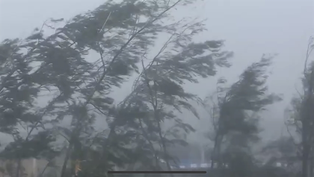
| Strong winds at Bạch Long Vĩ Island (Hải Phòng) were measured at about level 11 on the Beaufort scale. VNA/VNS Photo |
QUẢNG NINH/HẢI PHÒNG Typhoon Yagi has approached the sea area from Quảng Ninh to Thái Bình, with winds of up to 149kph near the storm's centre, according to the latest update from the National Centre for Hydro-Meteorological Forecasting (NCHMF).
As of 10am today, the centre of Typhoon Yagi (or Typhoon Number 3) was located at approximately 20.6°N, 107.6°E, over the Quảng Ninh-Thái Bình sea area. The maximum wind speed near the storm's centre is level 13 (134-149 km/h), with gusts reaching level 16.
The storm is expected to continue moving west-northwest at a speed of 15-20kph, making landfall in the northeastern region of Việt Nam. Winds are forecasted to be at level 8, with gusts at level 10. The risk of natural disasters in the northern Gulf of Tonkin, coastal areas, and inland regions of Quảng Ninh, Hải Phòng, and Thái Bình will be at level 4; while in the southern Gulf of Tonkin, coastal areas, and inland regions of Nam Định, Ninh Bình, and Thanh Hóa, it will be at level 3.
By 10am on Sunday, the storm is expected to move west-northwest at a speed of 15-20 km/h, weakening and gradually dissipating. Winds will be strong at level 6, and the risk of natural disasters in the northern Gulf of Tonkin, coastal areas, and inland regions of Quảng Ninh, Hải Phòng, Thái Bình, Nam Định, Ninh Bình, and Thanh Hóa will be at level 3.
Sea areas in the Gulf of Tonkin (including Bạch Long Vỹ and Cô Tô islands) will experience winds of level 8-10, with winds near the storm's centre reaching levels 11-13, and gusts up to level 16, with wave heights around 3-5m, with heights near the storm’s centre reaching 6-8m. Coastal areas from Quảng Ninh to Thanh Hóa will see waves of 2-4m, with heights near the storm’s centre reaching 3-5m.
Meteorologists also warn that coastal areas from Thanh Hóa to Quảng Ninh should be prepared for storm surges of 0.5m (in Thanh Hóa) to 2m (in Quảng Ninh) in the afternoon and evening of Saturday.
Areas for anchoring boats, aquaculture farms, and coastal dykes are likely to experience the impacts of strong winds, large waves, and storm surges. Low-lying and coastal areas, especially river mouths, should be vigilant for potential flooding due to storm surges and high waves.
From the afternoon of Saturday to the Monday morning, widespread heavy rain is expected in the northern region and Thanh Hóa, with total rainfall ranging from 100-300mm, and in some areas exceeding 450mm (the heaviest rain will occur in the northeastern region in the afternoon and evening of Saturday; in the northwestern region from the evening of Saturday to the night of Sunday).
Heavy rain is likely to cause widespread flooding in low-lying areas and flash floods in small rivers and streams, as well as landslides on slopes.
Due to the wide circulation of the storm, areas in the northwestern region and from Nghệ An to Thừa Thiên - Huế should be prepared for thunderstorms, tornadoes, and strong gusts.
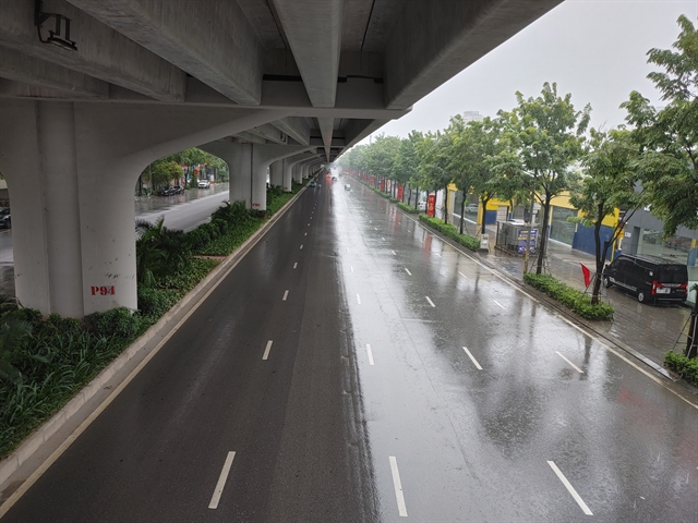 |
| Almost no traffic were present on Saturday morning in Phạm Văn Đồng street in Hà Nội. VNA/VNS Photo |
Although Hà Nội will not be directly impacted by the storm’s circulation, the city is expected to experience strong winds of levels 6 to 7, gusting to level 9 or 10 during Saturday afternoon and evening. This will significantly affect residents' daily lives, potentially causing tree falls, roof damage, and collapsing signboards, and the city is advising people to only go outside when it is necessary during these times.
In addition to strong winds, Hà Nội is likely to face heavy rainfall, with amounts reaching 150-350mm, which could lead to widespread flooding. Residents should prepare flood prevention and response measures for the city.
Meteorological experts warn that stormy weather poses numerous risks to both people and property, including damage to vehicles such as cars and motorbikes. People should avoid going out during rain and strong winds.
In areas directly affected by the storm, residents should secure their homes, reinforce roofs, elevate furniture if in low-lying areas, lower outdoor advertising signs, close windows and doors tightly, lower tall potted plants, anchor boats in sheltered locations, and secure aquaculture cages. They should also fully charge phones and other power devices, and prepare enough food and water for two days, as power and water supplies may be disrupted during the storm.
Families living in high-rise buildings should use adhesive tape to secure windows to prevent glass from being blown out by strong winds. Additionally, high-rise residents should bring heavy items such as potted plants from balconies inside and close windows tightly to prevent water from damaging flooring and furniture.
Management boards of apartment buildings should pay close attention to storm response plans and prepare water pumping systems in case of flooding.
Residents in coastal areas of Quảng Ninh, Hải Phòng, Thái Bình, Nam Định, and Ninh Bình, where the storm’s circulation will directly hit, should avoid going outside during periods of heavy rain and strong winds. In the northern mountainous and midland regions, as well as in Thanh Hóa, which face risks of flooding, flash floods, and landslides—especially in temporary housing, homes near construction sites, or downstream of reservoirs—authorities must immediately evacuate residents and their property if safety cannot be guaranteed. People should be moved to safe locations without delay. Even after the storm passes, the threat of flash floods and landslides will persist, so it is crucial to remain vigilant in the following days. VNS


: Ổn định")


: Cao nhất 124.000 đồng/kg")


: Đi ngang")